Winter weather outlook: Snow forecast not great, but all it takes is one

In the short term, the coldest air so far this season pushes into Richmond on Thursday, lasting a few days before moderating for the first of next week.
After clouds and small showers Wednesday, colder air rushes in overnight, making Thursday one of the coldest days so far this season. Only three days have not reached 60 degrees this fall, but that number will double before this weekend comes to a close.
The wind Thursday will be regularly 10-20 mph with some higher gusts, blowing the leaves around and making it feel like it’s in the 40s during the afternoon. No rain is coming on Thursday, but there will be lots of clouds developing on Thursday to mix with the sunshine.
First freeze coming?
This also means colder nights are ahead. So far this season, Richmond’s lowest official temperature was 36 degrees, on the mornings of November 10 and 13. The average date of the first freeze in Richmond during the 21st century is November 7, so we are long overdue. Moreover, as a testament to how much the climate has warmed, the average date of the first freeze during the 20th century was a week earlier — October 31.
Daybreak temperatures on Friday and Saturday mornings will be in the 30s, but whether or not we get a freeze depends on the wind speed. Lighter winds allow the ground to cool more effectively at night, but right now, it looks just windy enough to keep the temperature from tumbling below the freezing mark. Nonetheless, plan on temperatures in the lower to middle 30s when you step outside first thing on Friday morning, and upper 30s if heading outside early Saturday morning.
You may have heard some buzz about snow showers in Virginia’s mountains on Friday, but they will be confined to the highest elevations west of Interstate 81, in the counties sharing a border with West Virginia.
From late fall through early spring, cold air and strong northwest winds often bring snow showers and occasional heavier squalls to the western part of the state, but that snow rarely survives its trip eastward from the Blue Ridge. Nonetheless, some especially cold air will race by a couple of miles over our heads on Friday. The clouds that generate from that cold air just might — might — squeeze out some isolated snow flurries across Richmond.
Don’t be shocked to see them, but don’t go looking for them.
Weekend and Thanksgiving Outlook
That cold air will retreat slowly through the weekend, allowing for a small moderation in temperatures versus Thursday and Friday. No rain is expected this weekend, with Saturday afternoon in the 50s and Sunday afternoon creeping toward 60. Sunday looks a bit sunnier than Saturday.
After a recovery in temperatures next week, with afternoons in the 60s and lows in the upper 30s and 40s, the weather pattern becomes more unsettled starting on Wednesday. No singular dominant storm is ahead in the second half of next week, but a couple of smaller systems will pass through on Wednesday and Friday, touching off some showers or perhaps a few hours of rain over the holiday.
Looking further to the weekend of November 30, both days look dry and cold with afternoons in the 50s and nights in the 30s, marking the start of a weather pattern more typical for the time of year — more consistently with temperatures within a few degrees of normal.
Normal temperatures for the last week of November in Richmond:
- Highs: Mid-Upper 50s.
- Lows: Middle 30s.
So far this season, Richmond is having its third-warmest fall on record, and the upcoming weather pattern suggests it will remain one of the 10 warmest on record when we close the book on meteorological fall on November 30.
Those itching for a larger storm should bookmark the first week in December. There are preliminary suggestions of a more significant system either advancing from the Gulf of Mexico or developing near the North Carolina coast.
Winter expected to bring more of the same
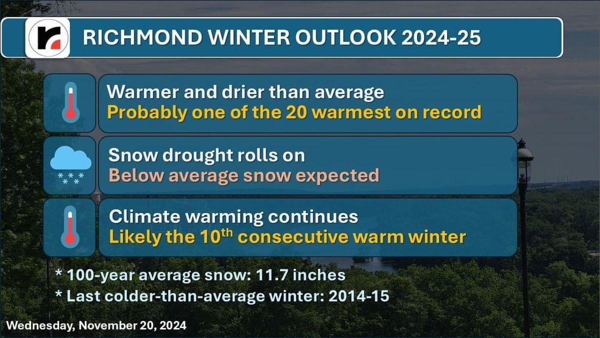
Regarding the winter outlook, which we define as the three coldest calendar months of the year (December through February), most signs point to a winter that is warmer and drier than average.
In addition to the background warming climate, a slow-moving pattern of Pacific Ocean temperatures in the North Pacific Ocean, called appropriately the Pacific Decadal Oscillation (PDO), will drive a jet stream pattern that makes it difficult to produce large snow storms across Virginia.
In concert with the PDO is another, more widely known driver of winter temperature and precipitation called La Niña (cooler than normal water in the central and eastern Pacific Ocean along the equator). The intensity of La Niña is still a bit of a question, but these two drivers suggest a continuation of the last few winters: warm with very little snow.
This does not mean there will be no cold spells, but added up over the entire winter, it will very likely be warmer than average. Each of the last nine winters has each been warmer than average, and we have unusually high confidence that this will be the tenth.
Between the ocean factors and the warming climate, this winter will likely be among the 20 warmest on record in Richmond.
Is it ever going to snow again?
Each of the last two winters has had less than an inch of snow, and although there is a temptation to believe “it doesn’t snow here anymore,” all it takes is one system at the right time with the right temperature pattern to send us well over the average amount of snow for the season. After all, Richmond is infamous for having feast or famine winters. The last two have obviously been famines. The last feast was 2009-10, with 28 inches.
Looking back over the climate record and expanding the snow window to the period between November 1 and March 31, the last winter season with more than a foot of snow was 2018-19, with 13.1 inches.
Out of 100 percent, here are our odds of total snow this winter in Richmond:
- 60%: Less than 5 inches
- 30%: 5-10 inches
- 10%: 10 inches or more
But as we often say about hurricane season, all it takes is one.


