

Helene's impact on Richmond, and remembering Gaston
After several days of social media chatter, Tropical Storm Helene formed Tuesday morning in the northwest Caribbean, heading north into the Gulf of Mexico where it will become a hurricane.
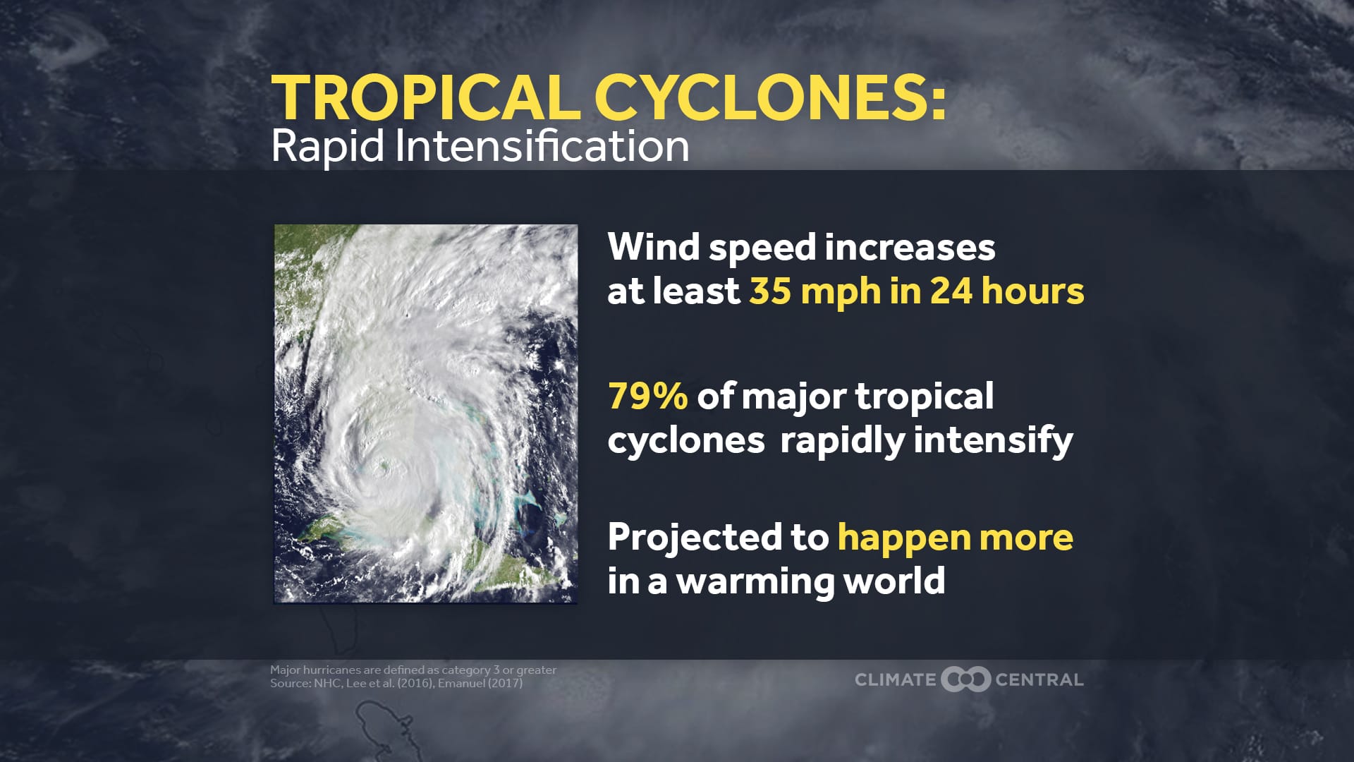
Conditions are favorable for rapid intensification, and a major hurricane is likely to take shape just before dawn Thursday. In meteorology, rapid intensification means something specific: the strongest sustained winds in the storm must increase by 35 mph within 24 hours. Similarly, a major hurricane is defined as one that is category 3 or higher, meaning its strongest sustained winds are at least 111 mph.
If rapid intensification seems more common, it is not your imagination. Evidence suggests that rapid intensification is becoming more likely as the climate continues to warm.
More specific to Helene, its center is forecast to come onshore Thursday evening along the Florida Gulf Coast between Pensacola and Tampa Bay, but its rain and coastal flooding will arrive several hours before the center moves from water to land.
For the most updated information leading up to landfall, the NOAA National Hurricane Center is the best place to start. Afterwards, the storm is most likely to turn slightly northwest after pushing across Georgia, with the center going into eastern Tennessee and Kentucky.
What Helene means for RVA
For Richmond, impacts come Friday.
That forecast track would send a few waves of rain into Richmond between Friday and Friday night before fading away into lingering clouds and spots of drizzle on Saturday. For the moment, the projected rainfall from Helene in Richmond is about an inch, but expect modifications in that forecast as the precise track comes into focus.
Considering the rain that has already fallen on Tuesday and additional rain on Wednesday, the potential for small-scale flooding by Friday night should not be dismissed entirely, but it is not an especially large threat in Richmond.
That same storm track, however, would bring substantially more rain to areas from the southern Shenandoah Valley to Roanoke, so western parts of the state should follow Helene more closely for flood concerns.
Helene will have spent more than 24 hours onshore before sending its rain bands to Richmond, so wind damage is not a concern. Nonetheless, within those smaller rain bands, enough spin is sometimes present in the atmosphere to form a tornado. Like the flood risk, the chance is low, but it should not be ignored.
Gaston and the Hidden Creek
Even after tropical systems have lost their intense winds, they carry a phenomenal amount of water. Richmonders only need to go back 20 years to remember the catastrophic flash flooding from Gaston in Shockoe Bottom.
Remember that the floodwall only guards against James River flooding. The flash flooding from Gaston came from an entirely different source: the old Shockoe Creek.
Shockoe Creek was around for centuries, with its headwaters originating just north of the modern day intersection of I-64 and Mechanicsville Turnpike. From there, it parallels I-64 toward Downtown, meeting up with additional tributaries (e.g., Cannon’s Branch) from the west and continuing toward its former entrance to the James River, near 17th and Dock Streets.
In the 1920s, Shockoe Creek was channelized and its lowest section piped and buried between Downtown and Church Hill, ultimately incorporating it into the city’s sewer and wastewater system. But the low-lying land remains, so when there is too much rain for the system to handle, the water piles up across Shockoe Bottom as it races its way to the James.
Specifically, that flood water originates from the Shockoe Creek and Cannon’s Branch watershed area north of the river — from Laburnum Avenue south to the James River and from Scott’s Addition east to Church Hill. So when rain falls within that 14 square mile area, it all drains toward the lowlands that once housed Shockoe Creek.
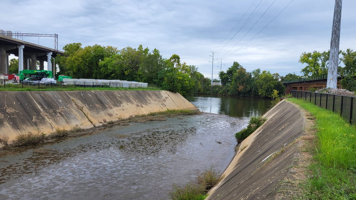
The original creek entrance into the James no longer exists, now it emerges near Richmond’s Iconic Triple Railroad Crossing, in a location now known as the Shockoe Creek Outfall.

You can find your neighborhood watershed area and what creeks are nearby by using the Richmond Department of Public Utilities site, RVAH20.
When will the sun come back?
After Helene comes ashore, the winds aloft that usually move weather systems from west to east are going to be clogged. As a result, there are signs that the remnant circulation of Helene might wander around the Tennessee Valley for a couple of days before picking up forward speed early next week, perhaps bringing more rain to Richmond on Monday or Tuesday.
We may have breaks of sun on Sunday, but overall, the next several days look cloudy and damp before the atmosphere becomes unclogged toward the middle of next week.


